All published articles of this journal are available on ScienceDirect.
Study on Three Dimensional Modeling and Visualization in Geology
Abstract
The display of three dimensional geological body can visually describe the complex subsurface geological structure, effectively improve the engineer's space imagination and intuitively understand the geological spatial relationship. Through analysis of commonly used three dimensional geological data model and considered the impact of faults. The paper establishes a generalized triangular prism (GTP) element model, and achieves a three dimensional geological modeling method based on GTP. The paper proposes the error correction technology based on virtual drilling, which allows designers combine their experience to appropriately amend the unknown region of stratum, it contributes to improve the accuracy of 3D geological model. Finally, the paper achieves a 3D geological drilling, borehole cross section, visual information query and geological visualization technology such as virtual drilling, cutting, layering display based on 3D spatial analysis techniques and graphics.
1. INTRODUCTION
The design and construction of railways, highways and urban rail transit are generally faced with more complex geological conditions. The traditional analysis and interpretation of engineering geological data are generally limited to 2D and static expression mode. Therefore, it is difficult to completely understand the geological environment. The 3D geological model can accurately and completely expresses complex geological phenomena boundary conditions and geological structures, and also can enhance the intuition and accuracy of geological analysis. These advantages let designers to make the engineering design and construction plan more in line with the actual distribution and variation of geological phenomena, and help to reduce project risks. Combining with the spatial analysis capabilities of three dimensional model, the paper establishes an effective method for 3D visualized analysis of geological information. This also has an important significance to determine reasonable route design.
2. THE DATA MODEL OF 3D GEOLOGICAL MODELING
2.1. Analysis of 3D Data Model
Due to the complexity of the geologic body and multiplicity of description character; a variety of spatial modeling models are formed. At present, the three types of 3D geological data models are surface-based, voxel-based and hybrid structure data model. Each kind of data structure has its advantages, disadvantages and applicable scope, therefore, how to select the appropriate mathematical models and spatial modeling methods to establish corresponding geological 3D model has become an urgent problem.
(1) Surface-based data model
The Surface-based data model defines and describes the spatial entities based on object boundary which focuses on the representation of three dimensional surface. Such as grid structure, patch model [1], section model [1], boundary representation model, wire frame model [1], multi-DEM model [2, 3] and so on.
(2) Voxel-based data model
The voxel-based data model uses voxel information instead of surface information to describe the internal of objects which concentrate on the representation of 3D space bodies. At present, Voxel-based data model mainly include 3D raster model, octree, constructive solid geometry (CSG), tetrahedron network(TEN) and so on [4-8], as shown in (Fig. 1).
(3) Hybrid structure data model
The Hybrid structure data model is synthesized by two or more data models to form an integrated structure data model, such as TIN-CSG, TIN-Octree, TEN-OCtree [9], WireFrame-Block hybrid structure data model and so on [10-12], as shown in (Fig. 2) [13].
For geological 3D body modeling, although the surface models can handle complex geological structure, but it is difficult to solve the display of internal properties, as well as the geological problems, such as cutting and mining. At present, the hybrid structure data model just stay in theory stage and only superficial integration [14], programming still has a lot of problems. Therefore, the voxel based modeling method is more and more used [15-19]. Among the voxel-based data models, generalized tri prism (GTP) model has the advantages of facilitating spatial query and spatial analysis which well meet the requirements of 3D modeling. Therefore, the paper uses GTP as basic voxel data model, and considering the influence of the complex geological structure for modeling, combining with the characteristics of borehole data and stratum distribution rules to build 3D geological bodies’ model.
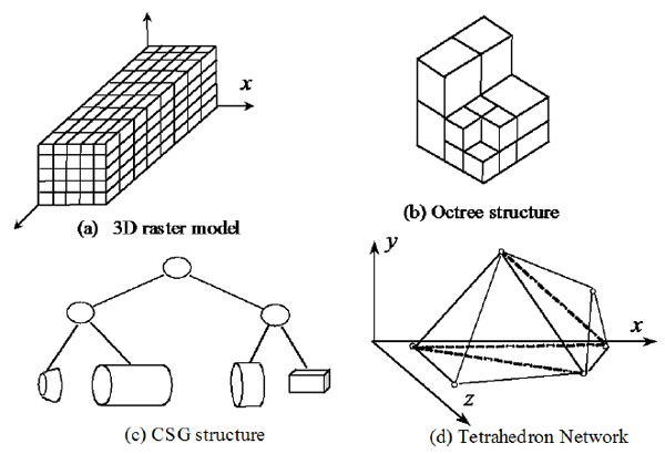
Voxel-based data model.
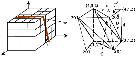
The schematic diagram of Octree-TEN.
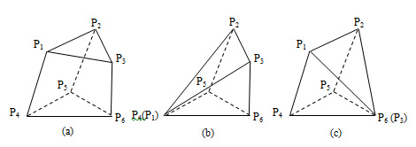
GTP data model.
2.2. GTP Data Model
GTP data model uses six kinds of basic elements and eight groups of topological relationships to describe and express 3D geological phenomenon, which can realize the rapid process of topological relations [2]. A GTP model takes GTP as the basic element and includes six vertexes: edge (edge, triangle), TIN triangle, quadrilateral and triangular prism body, as shown in (Fig. 3a). At the same time, against the geological pinchout, fault structure and other complex geological modeling GTP body elements can be deformed, as shown in (Fig. 3b, c).
GTP modeling method can well express the top and bottom surfaces, the internal structure and properties of 3D geologic body. The method fully considers the expression of topological relationships of GTP every element. GTP model directly based on the original drilling data, so the model conforms to the actual geological condition and ensures the accuracy of model, as shown in (Fig. 4).
GTP body element drawing.
3. three dimensional GEOLOGICAL BODY MODELING
three dimensional geological body modeling includes terrain surface modeling and underground 3D geological modeling, therefore, 3D terrain and underground data structure is the basis and core of 3D geological modeling. The paper takes GTP as basic voxel data model to build 3D geological body model. The basic flow of modeling is shown in (Fig. 5).
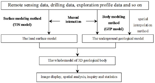
The basic flow of three dimensional geological modeling.
3.1. Terrain Surface Modeling
Because of the high cost of borehole data, often there is a finite number of drilling data in certain research area. Therefore, in order to make 3D geological body surface with high accuracy and reality in local region, Surface model uses digital elevation model data to full performance elevation changes in details, as shown in (Fig. 6).
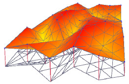
The terrain surface 3D modeling.
3.2. three dimensional Modeling of Underground Geological Body
three dimensional modeling of underground geological body is realized mainly through each underground stratum modeling, the main process of modeling as follows.
(1) According to the drilling hole coordinates, using the delaunay triangulation network construction method to generate a triangle, and set it as the upper triangle of the first GTP.
(2) Scaling down new triangle along three drilling holes according to the properties coding of upper triangle points, as shown in Fig. (8). The extended rules are as follows:
If triangle’s three vertices attribute codes are the same, the new triangle vertices are the next point of corresponding drilling hole, as shown in (Fig. 7a). If the code is not the same, the new triangle vertices will be the next point of corresponding drilling holes for the small code and remains the same as the upper triangle vertices for the large coding, as shown in Figs. (7b-d).
(3) According to the corresponding relationship between the upper and the lower triangle, construct the side edge, quadrilateral and generalized triangular prism, record and modify descriptor of the generalized triangular prism and set the lower triangle as the upper triangle.
According to the corresponding relations between upper and lower triangular to build the edge, side quadrilateral and generalized tri prism body, meanwhile, record and modify the description of the generalized tri prism.
(4) Repeat the steps α and β until all the upper triangle vertices are the bottom points of the three drilling holes.
(5) According to drilling hole coordinates, extends a new triangles through using Delaunay method and set it as the upper triangle, and then repeat steps from α to χ to build a new GTP.
(6) Repeat step δ until complete all the drilling holes triangulation.
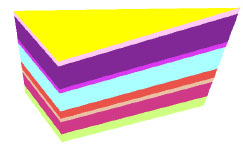
The advantages of this modeling method are easy to modify models. When inserting new drilling holes, it only needs to locally modify triangles along drilling holes and generate new GTP. 3D geological models are shown in (Fig. 8).
But the existence of complex geological structure such as faults destroys the continuity of strata, and changes the original distribution pattern of data. Therefore, the fault processing is one of the difficulties and hot spot in the 3D geological modeling and visualization [16]. Due to the discontinuity of fault structure's geometry space distribution, so the depth, width and extension direction of fault has a great influence on the location choice of large bridge and tunnel [20]. Therefore, the 3D geological modeling must consider the influence of the fault, the method is as follows:
The stratum data and modeling on both sides of faults, respectively stores and connects the same formation cut-off points of fault to constitute the whole 3D strata model, as shown in (Fig. 9).
The 3D geological modeling effect which existing faults is shown in (Fig. 10).

The downward extension of GTP.
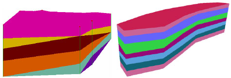
3D geological model constructed by GTP.
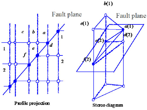
The schematic diagram of fault 3D modeling.
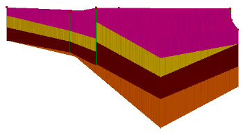
The effect of modeling of 3D geological model (including faults).
3.3. Three Dimensional Interpolation Algorithm
Although GTP voxel model has 3D hierarchical structure and spatial topological relations, but still cannot simulate the formation of the real shape characteristic, this also is a common problem which others data models are facing to. Its basic reason lies in the modeling data sparse.
If:
 |
(1) |
The cubic spline interpolation function is:
 |
(2) |
Among them, αj(x), βj(x) are primary functions, and calculated by the following formula:
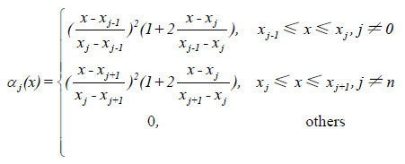 |
(3) |
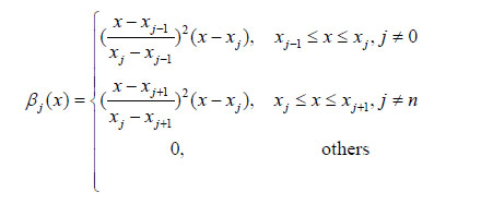 |
(4) |
mj is calculated by the following formula:
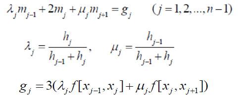 |
(5) |
Compares with the Lagrange interpolation polynomial, the cubic spline interpolation function can overcome the oscillation phenomenon and more accord with geological body shape.
3.4. Error Correction Based on Virtual Drilling Holes
The virtual drilling holes refer to the process of building underground geological body model, due to the need of modeling work in a specific location to add one or more of the controlling drilling holes with characteristics of imaginary. This drilling reflects stratigraphic information, which is not obtained by actual drilling work, but by the engineers’ deduction according to their working experience. In addition, the stratigraphic information of virtual drilling holes can be edited and constraints to the model again, therefore, the whole 3D strata model is updated and the geological modeling is more delicate and reasonable. The flow chart of 3D geological modeling which introduces virtual holes is shown in (Fig. 11).
The profile before adding virtual borehole is shown in Fig. (12) and after adding virtual borehole is shown in (Fig. 13) (the added virtual borehole ID is XNK_001).
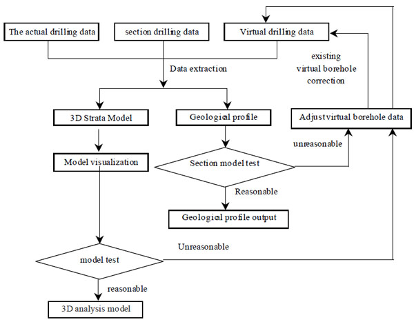
The flow chart of 3D geological body modeling which introducing virtual holes.
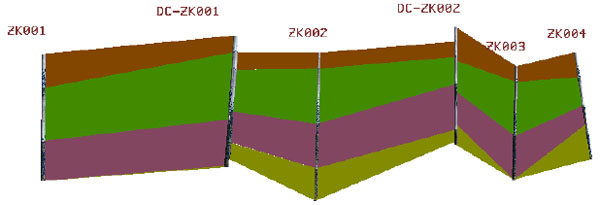
The profile before adding virtual borehole.
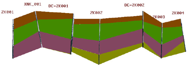
The profile after adding virtual borehole.
4. THE ANALYSIS AND VISUALIZATION OF ENGINEERING GEOLOGICAL 3D MODEL
4.1. Profile Query Between Drilling Holes
The three dimensional spatial information query is the basic function of 3D geological modeling and visualization, and it provides a powerful tool for spatial analysis. The purpose of visual query is to use 3D geological model which can get different scales of information from different sides and perspective. The visual query includes drilling query, drilling spatial query and drillings profile query. The results of 3D drilling query are shown in Fig. (14), drilling spatial distributions are shown in Fig. (15) and drillings profile query results from ZK00001 to ZK00007 as shown in Fig. (16).
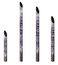
Three dimensional drilling query.
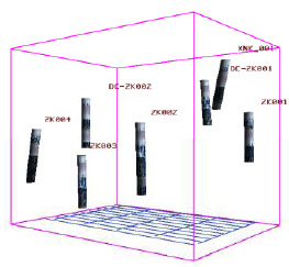
D drilling spatial query.
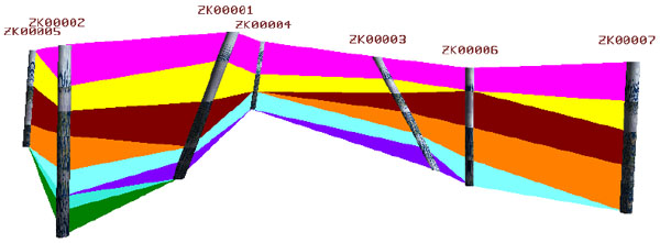
Drillings profile query (Considering the drilling practical inclination).
4.2. Visualization of 3D Model
In order to meet the need of intuition, comprehensive observation and analysis of designers, for a variety of different mode of visual expression is necessary. The main modes are as follows:
(1) Dynamic display mode. According to the demand of the observers, translates scales and rotates the 3D geological mode, so as to realize different angle, azimuth and distance of observation.
(2) Single display mode. Only displays one layer of 3D geological model in order to achieve the detailed understanding of the geological structure.
(3) 3D landscape mode. Allows from different angles and distance observes 3D geological model. Furthermore, through light and texture rendering technologies realistically expresses geological information, which can largely enhance the realism of the model.
(4) Perspective mode. Sets the texture or color of geological model in a certain transparency to penetrate the geological body which packaged outside of the 3D model, therefore, it can directly observe geological internal details.
(5) Section mode. Generates geological profile in any direction by cutting algorithm and profile drawing method of 3d model.
A variety of 3D geological model visualization expression is shown from Figs. (17-21).
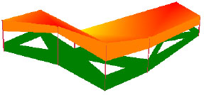
Select some strata displayed separately.
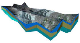
3D geological body.
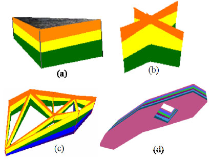
Different cutting pattern.
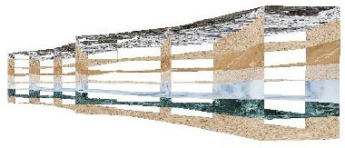
3D geological modeling based on cross fold profile.
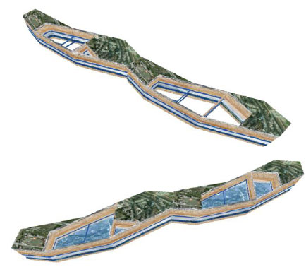
Effect of excavation in 3D geological model.
CONCLUSION
Through the analysis of the current 3D geological data model, under the condition of considering fault, the paper defines the GTP data model and realized 3D geological modeling method based on GTP. The paper puts forward error correction technology of the virtual borehole, realizes the auxiliary model of human-computer interaction and enhances the precision of 3D geological model. The paper also studies the analysis and visualization technology of 3D geological model, implements a variety of visual expression of 3D geological model, provides the strong support of multi-angle and comprehensive understanding of geological entity model. The research results develop an effective method of 3D geological information and comprehensive visual analysis.
CONFLICT OF INTEREST
The authors confirm that this article content has no conflict of interest.
ACKNOWLEDGEMENTS
This research was supported by the National Natural Science Foundation of China (Project No.: 51278316); the natural science foundation of Hebei Province, China (Project No.: E2014210111, E2014210152,); The Key Project of Education Department of Hebei Province, China (Project No.: ZD20131026, ZD2014084).

