All published articles of this journal are available on ScienceDirect.

Scientific Site Selection of Ancient Large-scale Underground Quarries from Engineering Geology: A Case of Shepan Island in Sanmen, China
Abstract
There are many ancient underground quarries in Zhejiang Province, China. Many caverns of them maintained steady more than 1000 years. Certain engineering geological condition is very important for long-term stability. In this paper, ancient underground quarries in Shepan Island are presented as a case. Shepan Island ancient large-scale underground quarry caverns are located in Sanmen County, Zhejiang Province. These caverns were excavated more than 800 years ago and at least 1300 of them are reserved until now. Shepan Island is a hill which uplifts the continental shelf extending to the gulf. There are no large regional fractures through caverns area, which indicates that it belongs to earthquake stability region. The caverns were excavated in thick volcanic clastic rock formed in the upper Jurassic, with NW and NE faults and NW joints. Based on the study of rock weathering, physical and mechanical tests of rock samples, and inverse analysis of structural plane, the huge thick volcano clastic rock can be classified as block structure. In addition, groundwater which affects the stability of caverns was analyzed based on the investigations of hydrogeological conditions. Site selection of ancient large-scale underground quarries is query scientific from modern engineering geology point of view.
1. INTRODUCTION
In the recent years, some ancient large-scale underground quarries were found. For example, more than 800 bell-shaped caverns in Bet Guvrin, Israel, have been explored by archeologists, and the caverns were excavated during the early Arabic period (7th-11th centuries) as stone quarries [1, 2]. Bazda underground quarries were excavated 3000 years ago(the oldest quarry in the world) in Sanliurfa, Turkey [3]. More than 2000 underground chambers have been excavated in the Wieliczka Salt Mine during the last 700 years in Poland [4, 5]. In Zhejiang Province, China, there are at least ten ancient large-scale underground quarries [6], such as Feifengyan Caverns were excavated about 700 years ago at Xianju [7]; Panlong Caverns at Huangyan had been excavated before 1644 A.D [8]; Yishi Caverns and Shanghuashan Caverns at Nibo began in 1297 A.D [9]; Heidong Caverns well kept over 1400 years at Tiantai [10, 11]; Changyudongtian underground quarry was excavated about 1500 years ago at Wenling [12].
Most of the ancient underground quarries include dozens, hundreds, or even thousands caverns, and many caverns have considerable size, large individual cavern span and shallow burial depth [10], such as, most of the Heidong caverns reach unsupported spans of more than 50m, even one reaches unsupported spans of up to 81m, which is far beyond the 50m expectation on current knowledge [13-15]. However, many caverns of them have maintained more than 1000-year-long stability. Except cavern structure and mining method, good engineering geological condition is very important for long-term stability of the caverns. In the paper, Shepan Island ancient underground quarries are presented as a case to study scientific site selection of ancient large-scale underground quarries from engineering geology.
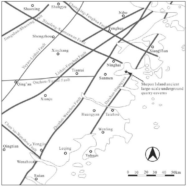
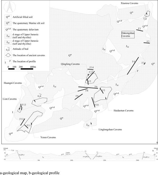
The Shepan Island locates in Sanmen Bay, east of Zhejiang Province, China. The caverns were excavated not less than 800 years ago, and at least 1300 of them are reserved until now, including eight separate cavern groups: Haidaotun Caverns, Yeren Caverns, Qingfeng Caverns, Lion Caverns, Huangni Caverns, Linglongshan Caverns, Dakengshan Caverns and Xiaotou Caverns [16]. The caverns are ancient large-scale underground quarries.
Shepan Island is a hill which uplifts the continental shelf extending to the gulf. The hill strikes NE. The main elevation of the hill varies from 40m to 70m, and the highest is 98.7m. The slopes are gentle with 15°~20°. There is a shoal around the hill with 2.4-5.2m elevation.
2. REGIONAL GEOLOGY
Shepan Island locates in the east edge of the South China continent (Fig. 1). It is a giant convergence zone formed by India - Australian plate, the Pacific plate and the Eurasian plate [17]. In this area, regional uplift and Ductile shear of Jiang Shao Fault occurred in Caledonian movement, strong skinned thrust slip in Indosinian movement while volcano - sedimentary cycles and the intrusion of magma in Yanshan movement were observed. Nowadays, the tectonics in the area orientated northeast are transformed later by NNE faults [18].
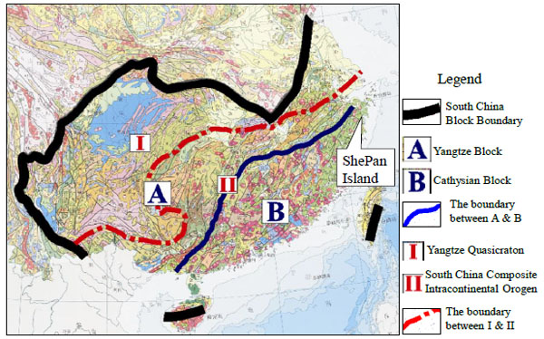
There are 2 regional faults near the Shepan Island, Xiaofeng-Sanmenwan Fault and Daishan-Huangyan Fault (Fig. 2) which may influence regional stability of the island. The Xiaofeng-Sanmenwan Fault strikes 300-310° with about 250 km long, and the Daishan-Huangyan Fault strikes 20-30° with more than 100 km, both faults are stable. The last activity of Daishan-Huangyan Fault occurred in Xiangshan during Middle Pleistocene [20].
According to Seismic ground motion parameter zonation map of China [21], seismic peak ground acceleration in Shepan Island is less than 0.05g It indicates that the basic earthquake intensity is less than VI. There are no strong earthquakes occurred in this area in the history. Therefore, the Shepan Island has seismic stability.
3. GEOLOGY OF SHEPAN ISLAND
The rocks in the Shepan Island were formed in d stage of Late Jurassic, and most of the rocks are is volcanic clastic rock, including various tuff, rhyolite and rhyolite porphyry (Fig. 3). The volcano stratums are 400-800m thickness.
From the ground surface to the lower part, the upper layer consists of weathered crushing rock with the thickness 0.7-1.7m. The lower part is the thick layer of gray purple pyroclast vitroclastic tuff, which is the main surrounding rock of the ancient caverns in the Shepan Island. There are 1 to 3 layers of tuffite strata, and the thickness of each layer is 5-10m.
The uniaxial compressive strength of slightly weathered saturated rock can reach the value of 66.76MPa which can be classified as strong rock according to State Standard of the People's Republic of China [23, 24], ISRM [25] and IAEG [26]. In addition, it is softening coefficient is 0.67, which belongs to the softening rock class (critical softening coefficient 0.75) (Table 1).
There are no regional faults through Shepan Island, but many small faults can be found in the island Fig. (3). Some of the faults appear in caverns and influence stability.
Most of the joints in Shepan Island are straight and closed, but some of them are slow wavelike. The length of most joints distribute in 4-10m, some can be 50m. Most spaces between joints are 5-10m. Dip angle of most joints in Qingfeng Caverns are steep, more than 80% of the joints are steeper than 60°, most joints in Qingfeng Caverns are NW trend [16].
| Material properties | Unit | Air-dried | Saturated |
|---|---|---|---|
| Density, ρ | g/cm3 | 2.47 | 2.54 |
| Natural moisture, w | % | 0.67 | 2.83 |
| Modulus of elasticity, E | GPa | 15.39 | - |
| Poisson's ratio, μ | - | 0.138 | - |
| Uniaxial compressive strength | MPa | 99.97 | 66.77 |
| Cohesion, C | MPa | 16.55 | - |
| Internal frictional angle, φ | ° | 48.2 | - |
| Tensile strength, σt | MPa | 8.63 | 6.92 |
4. HYDROGEOLOGY
Nowadays, all caverns are above the basic level of erosion. The topography of the island favors surface water discharge. However, there are four surface water bodies, such as Yanglan Reservoir and ponds, there are plashes in some caverns. The resource of the surface water is atmospheric precipitation.
Groundwater in the island can be divided into pore water and fracture water. Pore water is kept in quaternary gravely and muddy clay layers. Most of the water bearing layers is 0.3-2m thick, but some are more than 5m. The pore water is supplied by atmospheric precipitation and surface water. It flows to foot of slope and ditch with natural unwatering.
Fracture water is kept in rock fractures. Its permeability and water binding capacity are controlled by weathering, jointing and fracture connectivity. The fracture water is also supplied by atmospheric precipitation, and flows to surface. However, there is a little fracture water exudation from some cavern roofs.
From filed investigation, it has been concluded that the groundwater in the Shepan Island is poor, and the hydrogeology is simple.
5. DISCUSSIONS AND CONCLUSION
Nowadays, the ancient large-scale underground quarries in Shepan Island have been developed for tourism because of stone culture of Shepan Island. It consists of Shepan Stone (tuff and rhyolite), ancient quarrying methods and techniques, ancient large-scale underground caverns. Quarrying marks remain on caverns' wall [6]. It contains pristine scientific thoughts and superb skill. Site selection of the ancient large-scale underground quarries is scientific according to modern engineering geology.
From Fig. (2), it can be found that there are 2 regional faults near the Shepan Island, but they do not influence regional stability of the island. Fig. (3) can prove the opinion because there are no big faults in the cavern area. At the same time, there are no strong earthquakes in the area in history. Therefore, the Shepan Island is a seismic stability region.
According to engineering geological survey and existing data, the exposed strata in the Shepan Island can be divided into three sets from top to bottom, as described below.
(1) Huge thick volcano clastic rock group: It is the bottom layer which consists of red ocher tuff and rhyolite. There are little primary and tectonic discontinuities in this rock group.
(2) Medium thick volcano clastic rock group: It consists of offwhite and celadon sedimentary tuff and tuffaceous glutenite on the first rock group. Because of strong weathering and erosion, there are many discontinuities which penetrate in rock mass. Most of the rock groups are located in the upper of most of the caverns.
(3) Loose rock group: It consists of residues, slope deposits and completely weathered zones. The rock group is 0.5-1.5m thick. There is 10%-30% gravel with 2-15cm particle size.
Huge thick volcano clastic rock group is the main surrounding rock of caverns in Shepan Island. Most of the layers thickness is in meters or ten meters or even tens of meters. There are a few groups of primary discontinuities and tectonic discontinuities in the rock mass. Most of the discontinuities are well cemented, and there are some siliceous fillings. The rock belongs to strong rock with high elastic modulus and saturated uniaxial compression strength.
Based on Gu's rock structure classification [27], considering seven features (including geological background, spacing of structural plane, integrity index, characteristics of structural plane, appearance and strength of rock block, and hydrogeogical characteristics), the huge thick volcano clastic rock can be classified as block structure.
The Shepan Stone was quarried as slab and strip stone for building. Besides, slab stone was used to make door, window and in stone art [6]. Thus, dimension stone should be quarried. Because of intact rock mass and straight and closed joints, perfect rock block can be quarried. The Shepan Stone belongs to strong rock, ensuring quality materials for building and other usage. At the same time, it is no stronger than granite and other very strong and extremely strong rocks that favor artificial exploitation in ancient times.
The weathered zone in the Shepan Island is very thin. The thickness of eluvium, completely weathered zone and intensely weathered zone vary from 0.7m to 1.7m. In addition, groundwater in the Shepan Island is poor, and the hydrogeology is simple, which are favorable factors for mining.
CONFLICT OF INTEREST
The authors confirm that this article content has no conflict of interest.
ACKNOWLEDGEMENTS
The study is financially supported by the National Natural Science Foundation of China(41402269), Plan For Scientific Innovation Talent of Henan Province (154100510006), Key scientific and technological projects in Henan Province (152102210111), Scheme of young teachers of colleges in Henan Province (2015GGJS-105) and Support Program for Youth Innovative Talent of Science and Technology from North China University of Water Resources and Electric Power.

