All published articles of this journal are available on ScienceDirect.

An Investigation of Hydro-morphology Contributory Factors in Flooding and Sedimentation Problems on the Krueng Buloh River, Indonesia
Authors Info & Affiliations
Abstract
Introduction:
Process-based river hydrology and morphological analyses are infrequent, especially in developing countries. Climate change and the expected occurrence of major floods and erosion that could threaten the safety of nearby and downstream settlements, especially in areas that are very sensitive and affected by global warming, have made this kind of investigation necessary.
Methods:
The watershed of the River Krueng Buloh is prone to severe flooding, which has many social and economic effects on the villages nearby, such as the loss of crops and the destruction of buildings. However, the hydro-morphology and fluctuation of this river have not yet been studied. This research aims to determine which factors influence the stability of a river channel in the downstream region of the Krueng Buloh watershed following flooding or erosion.
Results:
To achieve this objective, field, and satellite-based observations of the hydro-morphology of a Krueng Buloh watershed have been performed. The investigation reveals that floods and sediment accumulation in the floodplain were triggered by excessive rainfall, the meandering of the river, and the riverbank soil type.
Conclusion:
The conclusions and methods given can be used to evaluate flooding and sedimentation in rivers for future operations to protect and preserve rivers.
1. INTRODUCTION
River systems are dynamic processes that change in terms of both longitudinal and lateral sedimentation and morphological persistence as a result of continuous resurfacing cycles [1, 2]. In addition, rivers are natural waterways that transport water from upstream to downstream. Moreover, changes in the morphology of a river can be attributed to both the increased intensity and frequency of floods and human activity over the past few decades [3]. In addition, as a result of erosion and sedimentation, changes in river morphology imclude bed level fluctuations and planform alterations (channel pattern, location, and width). In recent decades, the fields of study of hydrology and geomorphology have been combined by applying a morphological technique to concurrently account for physical parameters and stream processes [1, 4-6]. Furthermore, the evaluation parameters involved are a combination of hydrology, hydraulics, and geomorphology of the landscape of the river [4, 7, 8]. In principle, these evaluations can describe hydro-morphological evaluation approaches.
Indonesia is one of the most disaster-prone countries in the world, constantly experiencing earthquakes, landslides, tsunamis, volcanic eruptions, drought, and flooding [9, 10]. Spread throughout 6000 inhabited islands, people in Indonesia face several diverse risks, as well as differing levels of disaster response-ability, creating a challenge to preparedness and response to disasters [11]. In addition, Indonesia is situated between three tectonic plates (the Eurasian, the India-Australian, and the Pacific plates), two oceans (the Pacific and the Indian), and two large continents (Australian and Asian) [12]. Among the disasters that occur in Indonesia, river flooding is one of the most common. In Indonesia, there are around 5,590 major rivers, of which approximately 600 have created substantial flood risks [13].
Currently, Indonesia is dedicated to achieving sustainable development goals. One of the objectives is to take immediate action against climate change and its effects. This objective is essential for preventing climate change, the greatest threat to development, and for building resilience to climate-related hazards and natural disasters, which mainly affect the poor and the most vulnerable. Flooding has developed into a big issue in Indonesia over the last decade [14]. Excessive rainfall resulted in catastrophic disasters such as 5-year floods, monsoon floods, and flash floods, while extreme tidal backflows flooded the low-lying coastal region. Uncontrolled urban population expansion, inadequate land use planning, a poor understanding among city community members about floods and their catastrophe risk, and a lack of knowledge about disaster mitigation measures and preparedness all contribute to flood events turning into disasters [15]. In Indonesia, flooding is increased by annual rains even during the monsoon season. Between November and March, the wet season occurs, during which Asian and Pacific atmospheric circulation affects weather patterns. The dry season, which lasts from June to October, is determined by the Australian continent's influence [11].
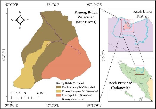
The flood phenomenon may even innately transform into a disaster event if it results in loss of life, life difficulties, and property damage that the affected people are unable to bear [16, 17]. Flooding is the most common type of disaster in Indonesia [18]. In terms of the types of disasters that frequently occur in Indonesia, flooding ranks first. According to the most recent data released by local authorities, at least 18,518 disaster events occurred in Indonesia between 1815 and 2015, with flood events accounting for 31.68% of all disaster events. At the provincial level, flood disasters accounted for 66% of all disasters in Aceh Province, with 559 cases recorded between 1970 and 2019 [18]. Flood events faced by residents of the Buloh area, which is located downstream of the Krueng Buloh Watershed, Aceh Province see Fig. (1), can be compared to cases of flood disasters that frequently occur in Aceh Province's east coast area. The catchment of the Rivers Krueng Buloh is susceptible to extreme flooding, which has numerous social and economic consequences on the surrounding villages, including the destruction of crops and structures. In general, prior scientific investigations into the flood phenomena have consistently shown that the inadequate carrying capacity of the watershed due to sedimentation and erosion as an ecosystem is one of the major causes of natural catastrophes related to water, notably in this instance flood disasters [19]. On the other hand, watershed deterioration can be increased by a growth in the use of natural resources as a result of population expansion and economic growth, conflicts of interest, and lack of integration across sectors, between upstream-middle-downstream areas [20, 21].
The river systems can be monitored using the geographical information system (GIS) and remote sensing technologies. These methods have been acknowledged as a valuable source of data for river morphology research. Numerous studies have been conducted over the previous decade using spatial analysis to determine flood and sedimentation management in vast areas [17, 22-27]. Geospatial analysis has been demonstrated to be an extremely scientific method for the development of exact and up-to-date data for the evaluation of watershed parameters. Additionally, it has great potential for controlling and measuring dynamic changes across large surface water bodies, as well as for extracting hydrological information and simulating the water balance [28, 29].
The primary objective of this study is to determine the most important factors that influence the stability of a river channel following flooding or sedimentation in the downstream area of the Krueng Buloh watershed. Moreover, this study aims to help fill in the hydro-morphological information gap by of the characteristics of the Krueng Buloh River. According to the preliminary research on the flood and sedimentation phenomena and the efforts undertaken so far by the regional government of Aceh Utara Regency, a complete hydro-morphological review of the elements contributing to numerous flooding events in the Krueng Buloh area has not been conducted. Additionally, flood control operations in the downstream section of the Krueng Buloh basin have not been organized or integrated, reducing the effectiveness of attempts to minimize flood disasters. Furthermore, water resource management is evolving from a top-down, monodisciplinary, single-sector approach to a multidimensional one, allowing for increased stakeholder input in planning and decision-making. The findings and discussed approach can be beneficial for flood and sedimentation assessment of future river protection and conservation activities.
2. STUDY AREA
Aceh Province is divided into nine major watersheds [30]. One of these is the watershed of the Krueng Buloh River, which covers 176.652 km2 area and spans 23.33 km. The river runs from the mountain region to the Krueng Geukuh areas in the southwest and southeast to northwest direction before reaching the sea (Fig. 1). Three sub-watershed parts of Buloh Watershed are Keude Krueng, Payah Leupah, and Krueng Manyang. Krueng Buloh River is in Aceh Utara District, Aceh Province, Indonesia. Buloh is a subdistrict of Aceh Utara. Buloh is located on Aceh Province's east coast, approximately 265 kilometers from the provincial capital, Banda Aceh. Among the 852 villages classified into 70 sub-districts in Aceh Utara Regency which is located downstream of the Krueng Buloh basin. With a generally warm and humid climate, rainfall averaging 200 mm, and several rainfall events ranging from 115 days per year (Table 1), the Buloh area frequently sees flooding during periods of prolonged rainfall [31].
| Month |
Rainfall (mm) |
Rainy Days (Days) |
Sunshine (%) |
|---|---|---|---|
| January | 7.3 | 3 | 78 |
| February | 55.8 | 6 | 71 |
| March | 19.8 | 3 | 76 |
| April | 248.7 | 13 | 64 |
| May | 433.9 | 18 | 56 |
| June | 140.8 | 8 | 70 |
| July | 177.6 | 11 | 63 |
| August | 3.0 | 1 | 67 |
| September | 64.2 | 6 | 40 |
| October | 75.1 | 9 | 43 |
| November | 225.6 | 16 | 47 |
| December | 374.5 | 21 | 38 |
3. MATERIALS AND METHODS
The study utilizes primary data gathered from a variety of sources, including surveys, interviews, previous research, government reports, and the Internet. In addition, the data was also collected from information from local and national governments and organizations, including topography, administrative borders, land cover, stream networks, hydrologic stations, and annual precipitation data. In detail, this analysis used a raster-based digital elevation model (DEM) that estimated elevations by using satellite pictures as input. These DEMs are employed in several types of research as repositories of topographic information because they are readily accessible and available worldwide. Particularly data-scarce locations utilize satellite-derived meteorological data, and these satellite technologies have emerged as a good source of data due to their free availability and ease of access. Using Landsat satellite imagery and the Google Earth Engine platform, the morphological changes of the Krueng Buloh Rivers were investigated. The Indonesia Meteorological and Hydrological Service supplied the meteorological and hydrological data used in the subsequent analysis indices. All data were georeferenced within the ArcGIS software using the UTM system of coordinates.
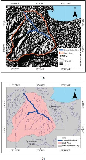
Arc GIS 10.8 was utilized to conduct the land use classification procedure and estimate the other values of morphological index variables. Landsat photos were retrieved from the USGS website to conduct the planform analysis. This satellite-based analysis was validated and confirmed by the results of a topographical survey done in the field. The geological structure of the Aceh Utara Regency and the surrounding area is dominated by quarter rocks along the coast (north) and tertiary rocks on the inland (southern). This distribution is consistent with the watershed's downstream to the upstream pattern, as well as with the topography that climbs from north to south [32] as in the DEM map in Fig. (2a). As in Table 1, January and August have the minimum rainfall days, while May and December have the maximum rainfall days. The soil type has a significant impact on the suitability of land for agricultural and non-agricultural development. An introduction to the properties and distribution of soil types is critical considering Aceh Utara Regency's attempts to utilize land/land resources. In general, Aceh Utara Regency's soil types can be classified into two primary groups: the dominant hydromorphic group near the shore and the dominant podzolic group inland. This characteristic is also consistent with the soil's effective depth, which follows a pattern from the shore to the interior, from the deepest (>90 cm) to the shallowest (30 cm).
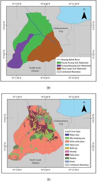
Fig. (2b) displays the river around the Krueng Buloh watershed area. Krueng Buloh watershed is subdivided into three approximately equivalent sub-catchments, as in Fig. (3a) and Table 2. The first sub-catchment, the Krueng Manyang catchment, is dominated by highland landforms and has an overall longitudinal slope of 0.0195%. The remaining parts of the Paya Leupah and Keude Krueng catchments are lowland areas characterized by rice paddies and settlements, with slopes of 0.0072 and 0.0130, respectively. Fig. (3b) depicts land use activities in the Krueng Buloh River Basin in 2022. This study classifies the sorts of land use activities into four categories: water bodies, forests, developed regions, and agriculture. The ratio of land use activities in the Krueng Buloh River Basin is presented in Table 1. With 164,295.36 hectares (59.65%), agriculture accounted for the highest proportion of land use activities in the Krueng Buloh River Basin. The majority of the agricultural area in the Krueng Buloh River Basin consists of coconut, oil palm, rubber, and rice. The agricultural activities will contribute to the economy of the area because they are a significant source of production, employment, and foreign exchange earnings [33]. Moreover, there are 61,318.51 hectares of forest in the Krueng Buloh River Basin (22.26%). Near the Krueng Manyang and Krueng Buloh dams, the forest covers the majority of the high-elevation region and the northeastern portion of the Krueng Buloh River Basin. Slope instability will result from human activities like deforestation and development. Land use patterns have been altered and the occurrence of landslides has grown as a result of human activities involving a transformation in land use patterns, particularly for the construction of communities and infrastructure. From Fig. (3b), paddies, and palm oil plantations, which employ more than 70% of the sub-population catchment, are the primary land uses. In the highlands of Krueng Buloh, there are dense forests. The rest of the area is farmland, grassland, and settlements.
| Sub Watershed |
Area (km2) |
Upstream Elevation (m) |
Downstream Elevation (m) |
Main River Length (km) |
Catchment Slope (%) |
|---|---|---|---|---|---|
| Krueng Manyang | 52,06 | 308,00 | 10.00 | 15.32 | 0,0195 |
| Paya Leupah | 71.59 | 114.00 | 10.00 | 14.47 | 0.0072 |
| Keude Krueng | 176.65 | 308.00 | 4.00 | 23.33 | 0.0130 |
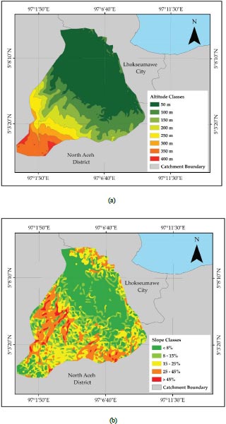
The slope map is an essential factor for analyzing the physical properties of distinct zones to determine their suitability [34]. The slope has a crucial function in identifying flood-prone areas; thus, it is one of the primary indicators of surface areas that are extremely susceptible to flooding. When a slope becomes steeper, the flow velocity increases, the concentration-time lowers, and hence the risk of floods reduces. On flatter terrain, water moves more slowly, collects longer, and accumulates, making these places more vulnerable to flooding than the steeper slopes [35].
In addition, the effect of terrain on erosion reveals the fact that erosion accelerates as steep slopes and slope length increase [36]. As in Fig. (4a and b), the large altitude is 400m which is the upstream area, and the lowest altitude is 50m in the downstream area. Most of the surface of the slope is composed of a layer of medium-hardness soil that has a high risk of erosion and landslides if it is not covered by vegetation [37, 38]. Due to the large difference in elevation and slope between the highlands and the lowlands in the Krueng Buloh watershed, erosion, and sedimentation happen in the upstream areas and bring the erosion material downstream. As a result, flooding happens in the downstream areas.
4. HYDROLOGY ANALYSIS
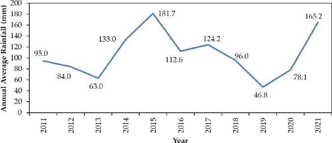
A hydrological study is an essential tool for analyzing the carrying capacity of a watershed as it is strongly associated with the ability for rainfall to be absorbed by the watershed, which will then provide a flow discharge that drains into the main river [39, 40]. The hydrological analysis process begins with an analysis of the design rainfall utilizing two methods for analyzing the frequency distribution and area rainfall distribution [30, 41]. Design rainfall was calculated using two types of distribution: Gumbel frequency analysis and Log Pearson Type III distribution analysis. As displayed in Table 3, the ultimate objective is to obtain the design rainfall to calculate the design flood discharge using specific re-turn period standards such as 2, 5, 10, 25, 50, and 100 years. Moreover, a hydrological analysis can be used to establish the design of flood discharge. This design flood discharge calculation has been widely applied in technical flood control efforts in Indonesia [13, 18, 42]. One parameter affecting surface runoff is the meteorological factor, which includes rainfall intensity, duration, and distribution, as well as watershed characteristics [18]. The watershed's characteristics include its size and form, geography, and land use. The average annual rainfall of Krueng Buloh from 2011 to 2021 was extracted from the nearest meteorology stations and displayed in Fig. (5). Most of the subdistricts in the Krueng Buloh watershed area were affected by flooding as a result of the heavy precipitation that was recorded throughout the year.
To accomplish this purpose, the reliability of the rainfall data must be evaluated to determine the adequacy of the distribution pattern for planning the maximum rainfall probability. After determining the amount of rainfall over various return periods, the design flood discharge can be computed. For return periods of 2, 5, 10, 25, 50, and 100 years, the flood discharge is calculated as in Table 4. The following step is to compare the volume of runoff in the Krueng Buloh watershed to the designed flood discharge for the various return periods mentioned. The elements affecting runoff are meteorological and include rainfall intensity, duration, and dispersion. Following the theoretical calculations for these hydrological and meteorological parameters, the critical stage is the computation of watershed characteristic factors, which include the watershed's area and form, topography, and land cover type [43]. To study a watershed's carrying capacity, hydrological analysis is required, particularly because it is directly tied to the ability for rainfall to be absorbed by the watershed, resulting in a flow discharge into the main river. Flood control, in its simplest form, refers to all strategies used to mitigate the adverse consequences of floodwater or the destructive power of floodwater. To measure the flood discharge, it is essential to measure the discharge directly on the river flow for a specified period. This is difficult to accomplish, as not all river bodies in Indonesia have an authorized agency-installed discharge monitoring system [44].
| Watershed |
Return Period (years) |
Log Pearson III (mm) |
Gumbel (mm) |
|---|---|---|---|
| Krueng Buloh |
100 50 25 20 10 5 2 |
229.12 211.22 192.14 187.26 164.61 141.09 102.35 |
267.12 239.75 212.17 203.22 175.00 145.58 101.14 |
| Sub Watershed |
Return Period (years) |
Flood Discharge (m3/s) |
|---|---|---|
| Krueng Manyang |
100 50 25 20 10 5 2 |
299.95 276.52 251.55 245.15 215.50 184.72 134.00 |
| Paya Leupah |
100 50 25 20 10 5 2 |
287.74 265.27 241.31 235.17 206.73 177.20 128.55 |
| Keude Krueng |
100 50 25 20 10 5 2 |
505.38 465.91 423.82 413.04 363.10 311.22 225.77 |
5. RIVER MEANDERING
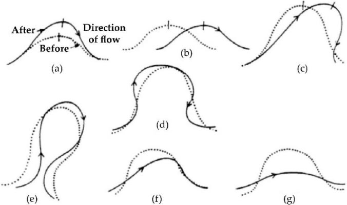
A meander is a shift in the river's flow that shapes a semicircle or the letter S caused by horizontal and centrifugal force. The process is characterized by erosion of the outer bank and sedimentation of the inner bank. This erosion and deposition are caused by the velocity and shear stress distribution imbalance in the curved river segments [45]. The previous study describes various types of meandering curve migration according to the direction and characteristics of the migrations [45]. The principle of an inflection point was utilized to differentiate between the various types of meander curves. These curves are illustrated in Fig. (6).
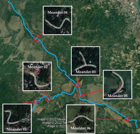
The meandering morpho-dynamics of the river were approximated using a spatial-temporal analysis of the river's planform utilizing free spatial data from Google Earth Pro as illustrated in Fig. (7). According to the results of an analysis of the morphology of the Krueng Buloh River, the Krueng Buloh has a river depression or a regularly meandering river with a turn direction that reaches a semicircle. Sometimes, the bend is separated from the river's main flow because the water is running backward and breaking through straight. By analyzing the constituents of meandering channels, four curve migrations of stream channels were determined. The four modes of the curve are conversion to a compound loop, diagonal cutoff by chute, extension, and translation as in Table 5. The meandering zone exhibited characteristics of a limited channel belt, including slope, hydrodynamic forces, decreased curvature, and migration velocity [46]. From field investigation, the stream belt is narrow and deep, and the sediment is silt. Because of the weather and the plants, some swamps and depressions produce organic matter and are made of mud-packed silt. With continual migration and modification of the channel, superpositions form extensively, and the reservoir maintains continuity [47]. Identifying the sort of curve migration is crucial for any prospective riverbank protection and conservation service. The engineers can implement the appropriate measures for each river curve.
|
Curve Meandering Number |
Meander Length (m) |
Type of Curve Migration |
|---|---|---|
| Meander 01 | 270 | conversion to a compound loop |
| Meander 02 | 182 | translation |
| Meander 03 | 188 | extension |
| Meander 04 | 275 | diagonal cutoff by chute |
| Meander 05 | 140 | extension |
| Meander 06 | 230 | translation |
| Samples |
Gravel (%) |
Sand (%) |
Silt-Clay (%) |
USCS Classification |
AASHTO Classification |
|---|---|---|---|---|---|
| H01 | 0.00 | 22.40 | 77.60 | MH | A-7 |
| H02 | 0.00 | 7.84 | 92.16 | MH | A-7-5 |
| H03 | 0.12 | 10.86 | 89.02 | MH | A-7 |
| H04 | 0.00 | 6.82 | 93.18 | MH | A-7-5 |
| H05 | 0.96 | 15.44 | 83.60 | MH | A-7-5 |
| H06 | 8.72 | 39.62 | 51.66 | ML-OL | A-4 |
| H07 | 0.00 | 34.32 | 65.68 | MH | A-7 |
| H08 | 0.00 | 55.04 | 44.96 | ML-OL | A-4 |
| H09 | 0.00 | 39.98 | 60.02 | ML-OL | A-4 |
| H10 | 0.70 | 53.58 | 45.72 | ML-OL | A-4 |
6. SOIL SAMPLING
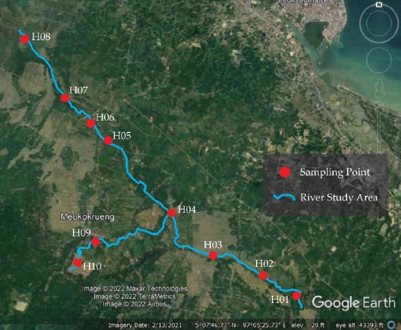
One of the primary causes of surface sediment transport in the watershed area is soil erosion. This increases the quantity of sediment transported downstream by river flow. Naturally, the characteristics and erodibility of the soil and the climate conditions are the causes of land erosion. In addition, the soil will be carried by water and deposited as temporary or permanent sediment somewhere downstream. To investigate the physical parameter of the river slope material along the Krueng Buloh, field sampling was conducted at ten locations as can be seen in Fig. (8). Understanding the fragility of the upper layer of soil requires knowledge about the soil's condition, as susceptibility to erosion varies with soil parameters [48]. Soil samples were extracted with the assistance of a hand auger and immediately placed in sealed plastic bags. This method offers grain-size data from a sampling area.
In addition, soil type and texture have a substantial impact on the infiltration rate and the surface-to-infiltration rate relationship, which ultimately affects flood vulnerability. The soil type is a crucial factor in determining the water-holding capacity and infiltration characteristics of a region, both of which influence the possibility of flooding. The chance of flood risk increases when the capacity of infiltration of the soil decreases, resulting in a higher surface flow. When the rate of infiltration is exceeded by the water amount supplied, such as rainfall or irrigation, water will flow downward slope as runoff on sloping terrain, which can result in flooding.
The grain size distribution of river slope material is determined based on laboratory analyses of samples obtained at 10 locations Table 6. The laboratory grain size was used to analyze the grain size distribution of the riverbed materials. According to Table 6, silt-clay particles are the predominant soil type along the Krueng Buloh River within the range of above 60%. Moreover, the USCS and AASHTO soil classifications are dominant with MH and A-7, respectively. This type of soil is vulnerable to the processes of erosion and sedimentation and relatively impermeable [1]. Additionally, this sort of soil has poor shear strength, which can enhance the erosion process [49, 50].
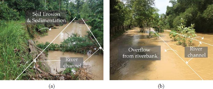
Field and satellite-based measurements of the hydro-morphology of a Krueng Buloh watershed were conducted to meet the research objectives. The Krueng Buloh watershed is a frequently flooded zone. The area around the Krueng Buloh watershed is likely to flood because of its topography, soil types, rainfall, hydrology, and geomorphology. According to the investigation, the frequency and flow of water drop dramatically during the dry season. During the rainy season, the water level rises significantly and floods the surrounding area. Moreover, floods and sediment deposition and accumulation in the floodplain were caused by excessive rainfall, the river's meandering, and the riverbank soil type. As shown in Fig. (9a and b), erosion occurred, particularly during the rainy season, resulting in sedimentation and flooding downstream. Normal river channels have shifted over time due to erosion, resulting in an overflow of water from the riverbank. The presented conclusions and methods can be used to study river flooding and sedimentation as part of future efforts to protect and preserve rivers.
7. RESULTS AND DISCUSSION
There are three sub-watersheds in the Krueng Buloh watershed of Aceh Utara Regency, including Keude Krueng, Payah Leupah, and Krueng Manyang. These rivers go from upstream through the southern highlands to discharge into the Malacca Strait in the northern coastal region. Krueng Buloh District is prone to flooding. This research aims to discover the factors that influence the stability of a river system in the downstream region of the Krueng Buloh basin following flooding or erosion. Through the hydro-morphological assessment of the Krueng Buloh river, this research intends to contribute to filling this knowledge gap. To accomplish this goal, field, and satellite-based investigations into the hydro-morphological of the Krueng Buloh basin were conducted.
Indonesia is currently determined to achieve sustainable development objectives. One of the goals is to take quick action against climate change and its consequences. This goal is important for reducing climate change, which is the biggest threat to development, and making people more resilient to climate-related risks and natural disasters, which hurt the poor and vulnerable the most. Local governments should adopt and implement community-specific disaster risk reduction policies to address the flood problem. Since the effects of disasters are experienced most strongly and immediately at the regional level, it is crucial to adopt measures at the regional level to reduce existing danger, prevent risk development, and enhance the resilience of cities. Regional risks also exist, and many of the most crucial instruments for reducing exposure risk, such as land use regulations, basic protection of the environment, and compliance requirements functions, which are essential for effective disaster prevention, are incorporated at the regional level. Regionally, authorities and communities should collaborate effectively to reduce catastrophe risk, promote sustainable development, and protect the environment.
CONCLUSION
The Buloh watershed area is at risk of floods due to its topography, soil type, rainfall, geology, and geomorphology. According to the satellite and field investigation, floods and sediment accumulation in the floodplain were caused by excessive rainfall, the meandering of the river, and the riverbank soil type. In addition, flooding in the Krueng Buloh area is mostly caused by a reduction in river capacity due to river meandering transformation, either in the river body or at the river mouth, as a result of excessive sedimentation. Given the proven destruction within the sub-catchment caused by flooding and sedimentation, the findings of this study apply to the planning and construction of sustainable flood risk mitigation approaches.
CONSENT FOR PUBLICATION
Not applicable.
AVAILABILITY OF DATA AND MATERIALS
The authors confirm that the data supporting the findings of this study are available within the article.
FUNDING
This research was funded by Universitas Syiah Kuala, Awards/Grant number: Penelitian Disertasi Doktor 2022 No. 145/E5/PG.02.00.PT/2022.
CONFLICT OF INTEREST
The authors declare no conflict of interest.
ACKNOWLEDGEMENTS
The intelligibility and scientific methodology of the paper was considerably enhanced by the comments and suggestions of the reviewers, for whom the authors are extremely grateful.

