All published articles of this journal are available on ScienceDirect.

Assessing IGS Network and Free Web-based Online GPS Services Accuracy with Session-duration Variation
Authors Info & Affiliations
Abstract
Background
The objective of this research was to evaluate online Post-Processing Services (PPSs) and Global Navigation Satellite Systems (GNSS) software in order to determine the significance of space geodesy techniques in assessing accurate coordinates for mega projects worldwide.
Methods
Principally, literature in the field of space geodesy techniques was assembled and scrutinized. Trimble R4 was utilized to observe 4 ground surfaces (i.e., asphalt, grass, sand and concrete), in Al-Azhar University, throughout 5 Session-Durations “SD” (i.e., 1, 2, 3, 4 and 5 hr.). The observed results were processed by TBC (i.e., It utilizes the International GNSS Service “IGS” network) and by 3 online services (i.e., Trimble Center Point RTX, AUSPOS and CSRS-PPP). Results were obtained, contrasted, and analyzed.
Results
The IGS results were compared in terms of SD, where it was clear that, regardless of surface type, SD has an insignificant influence on Easting, as Northing, but has an influence on elevation accuracy, especially for the 2hr-SD. In addition, the 3 online software services were contrasted against IGS results in terms of the different SDs, where it was clear that, regardless of the surface type, AUSPOS, CSRS-PPP and Trimble-RTX accuracies were arranged in ascending order, the 3hr-SD achieved accurate Easting so as Northing; while IGS 5hr-SD provided optimal elevation accuracy.
Conclusion
Accordingly, the research recommended that GNSS users make informed decisions according to the accuracy requirements due to time constraints while establishing data processing strategies to designate strengths and weaknesses of processing and to optimize GNSS data processing applications.
1. INTRODUCTION
GNSS encompasses many satellite technologies such as GPS, Galileo, GLONASS, Bei Dou QZSS and IRNSS in the USA, EU, Russia, China, Japan and India, respectively, where their positioning and navigation system are based on artificial satellites. However, GPS was mostly implemented for position, navigation and timing during the last 30 yr [1-4].
Any project has to fix its control points to designate its coordinates, where thework depends on them and their accuracy. Accordingly, when a new point is fixed in the site, a known point in its vicinity should be convenient [5]. In case of its absence, global stations should be implemented, where they are free online and with accurate coordinates to enable the designation of the control point. Consequently, other points could be designated by using this point. The research contributes to improving the accuracy of GPS services in daily life, as this higher accuracy will reduce errors in location information.
GPS has several applications due to its accuracy that reaches the sub-centimeter level. This could be achieved by utilizing appropriate processing techniques [6], where it is categorized into relative- and absolute positioning, as follows:
1.1. Relative-positioning
It acquires 2 GPS receivers to carry out instantaneous observations that are to be processed together. Accordingly, a baseline is created between them, where the coordinates of one of them are known [7]. In addition, its accuracy ranges between decimeters “dm” and mm [6, 8]. GPS user has relative positioning techniques to attain highly accurate coordinates [9]. However, in Egypt, GPS technology is acknowledged by mapping bodies.
1.2. Absolute-positioning
It is relatively economical and easier to utilize, in reference to the Differential Global Positioning System “DGPS,” as it acquires one receiver only. It utilizes the trilateration concept that acquires 4 satellites to determine the user’s position [10]. It is categorized into Single Point Positioning “SPP” and Precise Point Positioning “PPP,” where SPP utilizes a pseudo-range that has lower accuracy of a meter and is implemented for navigation purposes [11].
1.3. PPP
PPP is a technique that utilizes an analogous carrier phase as a pseudo-range in order to determine the user position, where PPP achieves DM accuracy [12]. PPP has measurement errors (i.e. ionospheric delay-tropospheric delay-relativity, delay-ocean tide loading-code biases-antenna phase offset-antenna phase windup and satellite clock error), that are modeled and minimized by models, where listed the impact of each error [13].
On the other hand, highlighted that PPP utilizes accurate satellite position and satellite clock, where their information is available in ephemerides (i.e., data of places of celestial bodies provided on regular intervals basis) [14]. Ephemerides is a product of IGS Analysis Centers “AC” that utilizes a global Continuous Operating Reference Station “CORS,” [15].
IGS classifies the ephemerides into four (i.e., broadcast ephemerides-ultra rapid ephemerides-rapid ephemerides-final ephemerides) [16]. as follows:
1.3.1. Broadcast Ephemerides
Broadcast Ephemerides are attained from GPS from monitor stations observations [10]. They are predicted routes obtained from GPS signals (i.e., satellite messages) where the information is in Keplerian parameters with progressive alterations [17].
1.3.2. Ultra-rapid Ephemerides
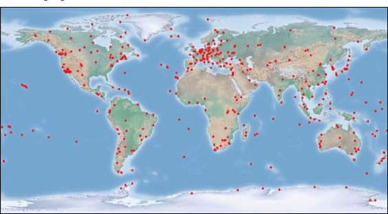
Ultra-rapid Ephemerides , as rapid- and final-rapid ephemerides, are orbital products that are known as “precise ephemerides”, which are generated worldwide by IGS analysis centers (i.e., CORS from the IGS network). Fig. (1) designates worldwide IGS stations.
1.4. Synopsis of Online Post-processing Services
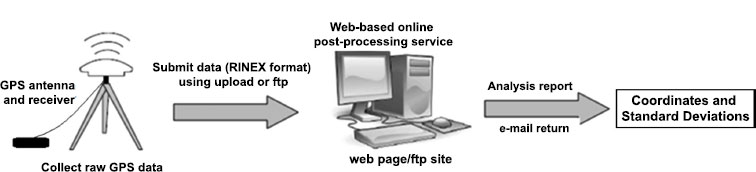
GNSS online PPSs are utilized worldwide to substitute traditional processing methods, as their utilization became widely popular due to the ease of its implementation, which has low-cost fees and does not require a license or knowledge of a GPS-processing [18]. GNSS data should be converted by the users to Receiver Independent EXchange (RINEX) format and sent via email or by uploading them to a specific website [19]. The uploading process after the coordinates could be easily obtained via the user email. However, it is possible to process data of positioning modes (i.e., static and kinematic) by a free online engine, which is web-based processing. Fig. (2) presents the processing method, which is web-based processing. Fig. (2) presents the processing method, which is online-based GNSS [20, 21].
PPSs encompass many services, where 3 were implemented in this study (i.e., AUSPOS, CSRS-PPP and Trimble Center-Point RTX). These are elaborated as follows:
1.4.1. AUSPOS Online GPS Processing Service
AUSPOS is an online program of Geoscience (i.e., static-GPS position) that was developed in Australia. It offers a modest web interface that links GPS operators to the processing program. It is worldwide implemented as an online means for pre-processing of GPS data in Geomatics Engineering, Geodesy, Geophysics, Forestry, Military and other domains. It was established in 2001.
Double frequency GPS devices could analyze static GPS Data for 1 hr. However, it is advised to be 2 hr. or more. On the other hand, kinematic GPS data cannot be pre-processed with online programs [22]. Moreover, when the RINAX data file is sent to the web server, it is analyzed according to the closest stations of the Asia-Pacific Reference Frame “APREF” and International GNSS Service “IGS.” These are reference points for correct orbit details to recover the data. However, the IGS14 antenna center variance model is utilized by AUSPOS Software [23], where AUSPOS is available on its website: https://gnss.ga.gov.au/auspos.
1.4.2. CSRS-PPP Canadian Spatial Reference System
CSRS-PPP utilizes GNSS orbit ephemerides to produce precise coordinates, regardless of GNSS user's location from the base, where GNSS data post-processing is a free online program to determine high precision observations [24].
RINEX observations files could be sent from GNSS via internet and their final coordinates will be International Terrestrial Reference Frame “ITRF,” [25, 26]. Further CSRS-PPP information is in (CSRS-PPP, n.d.).
1.4.3. Trimble Center-point RTX Post-processing
In -2011, Center-Point RTX emerged to provide cm accurate locations for static and kinematic applications, where RTX is accessible via the website and could be implemented by Trimble users [27]. Moreover, the Trimble GPS corporation provides an open web platform for PPS [28]. Trimble Center-Point RTX has high-precision performance and has fast integration capabilities. It is well-known by users in mapping tools (i.e., Trimble RTX has been active since 2012 [29]. It is Trimble website, www.trimblertx.com/UploadForm.aspx.
2. DATA AND METHODS
This research originated with the main objective of opting the technique that achieves accurate coordinates to mega projects by assessing and contrasting the automatic processing performance of Trimble Center Point RTX post-processing, AUSPOS and AUSPOS against GPS processing solution software (i.e., Trimble Business Center “TBC”) that assists surveyors to convert field data of receivers to information with high-quality.
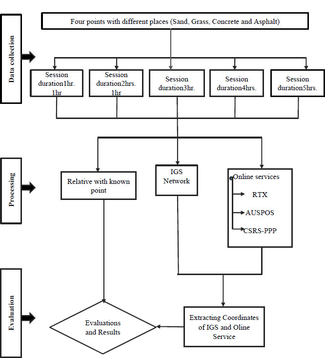
After setting the objectives, methodology, Fig. (3) was laid to encompass the following.
2.1. Site Visits and Data Assembly
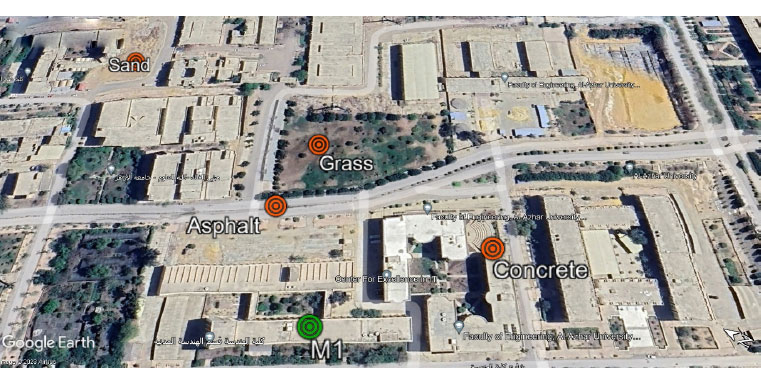
Several site visits were carried out to Al-Azhar University. Data was assembled for 15 days from 4 points with different materials (i.e., concrete, grass, asphalt and sand), where Fig. (4) presents the 4 points together with the M1 point that was considered the reference point; Fig. (4).
During the 15 days, data was assembled throughout 5 SDs (i.e., 1, 2, 3, 4 and 5 hr.), where the assembled data were GPS observations undertaken by 2 dual-frequency receivers (i.e., Trimble R4 GPS system).
| Service or SoftWare | Post-processing Mode | Website | Organization | Reference Frame |
|---|---|---|---|---|
| AUSPOS | relative (static) | https://gnss.ga.gov.au/auspos | Geoscience (Australia) | ITRF2014 |
| CSRS-PPP | Static, kinematic | https://webapp.geod.nrcan.gc.ca/geod/tools-outils/ppp.php | Natural Resources (Canada) | ITRF2014 |
| RTX | PPP (static) | https://trimblertx.com/ UploadForm.aspx | Trimble | ITRF2014 |
| TBC | relative (network adjustment) | Obtained from GNSS Trimble receivers | Trimble | WGS84 |
2.2. Processing Data by TBC and AUSPOS, CSRS-PPP, Center Point RTX
The GPS operators introduced the RINAX file (i.e., in RINEX format) into the online system and the GPS receiver Coordinates location is obtained within a short time, where Table 1 outlines these services as software.
The GPS data were processed by TBC software. The IGS accurate orbits were obtained from CDDIS. NASA.GOV, whereas the reference stations of ELAT, DRAG, RAMO and BSHM were selected as control points.
Moreover, the web-based services were implemented to process observed data, where accurate data (i.e., from Trimble Center Point RTX “trimblertx.com,” AUSPOS “Geoscience Australia,” and CSRS-PPP “Natural Resources Canada”) were obtained.
3. RESULTS AND DISCUSSION
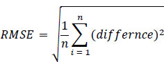
After processing the services as software during 15 days GNSS observations to the 4 stations by the software listed in Table 1 , results were obtained and analyzed, where the analysis method is based on R oot M ean S quare E rror “RMSE” technique (i.e., RMSE is squared differences between base and estimated 4 points coordinates), (Eq. 1).
The analyzed data were discussed, and this section is devoted to presenting the results discussion of TBC processing, online processing and TBC versus online processing, as follows:
3.1. Evaluation of IGS Network
Table 2 is provided, which presents the TBC processing results and lists the coordinates of the 4 observation points (i.e., before and after processing).
| Point | - | Before Processing | After Processing |
|---|---|---|---|
| Asphalt | E | 337645.82 | 337645.036 |
| N | 3326288.955 | 3326283.205 | |
| H | 91.651 | 88.164 | |
| Grass | E | 337700.517 | 337700.182 |
| N | 3326285.872 | 3326284.011 | |
| H | 91.276 | 90.327 | |
| Sand | E | 337708.111 | 337707.597 |
| N | 3326460.885 | 3326461.425 | |
| H | 87.153 | 90.305 | |
| concrete | E | 337676.072 | 337676.643 |
| N | 3326143.717 | 3326141.224 | |
| H | 109.036 | 106.501 |
However, it is of significance to mention that:
• The Position Dilution of Precision “PDOP” and the precise ephemeris were used for post-processing by the Trimble business center in the UTM zon36 and WGS 84.
• The 4 points were connected to a known coordinate point, “M1”, where the distances between M1 and the 4 points were not equal (i.e., asphalt, grass, sand and concrete were at distances 83.644, 126.341, 261.538 and 122.400 m, respectively).
• Two receivers were utilized simultaneously, where one receiver occupied the M1 known coordinate (i.e., reference or base) and 2nd occupied unknown points (i.e., rove).
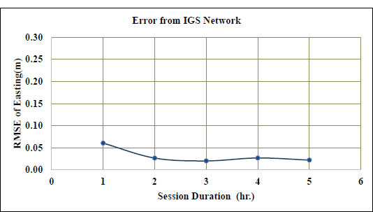
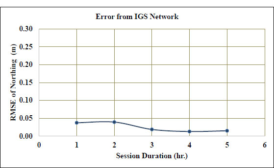
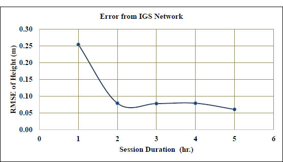
Figs. (5-7) are provided, where they present the designated RMSE, after processing the observations and extracting the correct coordinates, for the 5 SDs, for the Easting, Northing and elevation, respectively.
However, it is significantto mention the following:
• After recording the 4 points observations for the different SDs (i.e., 1, 2, 3, 4 and 5hr) using a dual-frequency receiver (i.e., Trimble R4 GPS) and extracting observations files, TBC software was utilized to produce an accurate coordinate system, in terms of Worldwide/UTM zone 36 WGS-84, where all observations data were introduced to TBC Software (i.e., with .0T02 extension).
• Precise satellite orbits were downloaded to TBC. However, IGS reference stations (i.e., BSHM-ELAT-DRAG-RAMO) were used as control points from the SOPAC site with RINEX format.
Figs. (5-7) indicate the following:
• For all SDs, no significant difference was detected with respect to the Easting and Northing.
• Relatively better RMSE values were obtained in the Easting (i.e., 0.02 m at 3hr-SD and 5hr-SD).
• The RMSE of the elevation was very big for the 1hr-SD (i.e., 0.25 m). However, this value decreased for the 2, 3, 4 and 5hr-SDs (i.e., 0.06 m)
• The 3hr-SD could be sufficient to obtain better accuracy in the Easting and Northing coordinates.
• As for the elevation, 5hr-SD is recommended to attain elevation accuracy.
3.2. Evaluation of Online Processing
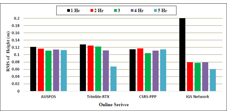
Figs. (8-10) are provided. They present the RMSE of the online processing results for the 5 SDs, for the Easting, Northing and elevation, respectively.
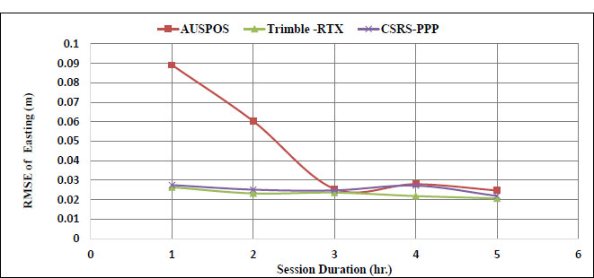
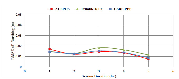
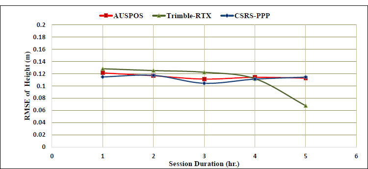
However, it is important to mention the following:
• After online results processing, adjustment of the observations was achieved, and final accurate coordinates, X, Y, and Z, from TBC software were obtained.
• All the observed data files were converted into RINEX format and introduced to online services (i.e., AUSPOS, Trimble RTX and CSRS–PPP).
• Each online service provided some products (i.e., results, graphics, and final coordinates, with their standard deviation). These products were emailed to the researcher.
• The corrected observations from online services were subtracted from the relative coordinates, and the RMSE was obtained.
Figs. (8-10) indicate the following:
• RMSE values were influenced by the SD.
• Significant variations were observed in the Easting, Northing and elevation RMSE values.
• The RMSE values order of AUSPOS, CSRS-PPP and Trimble-RTX were descending (i.e., 0.05, 0.03 and 0.02 m, respectively).
• Online services provided variable RMSE values in Easting.
• All online services provided similar RMSE values in Northing, with averages of 0.014, 0.13 and 0.13 for Trimble-RTX, CSRS-PPP and AUSPOS.
• For the elevation, the obtained RMSE values from Trimble-RTX, CSRS-PPP and AUSPOS were close, with an average value of 0.1, 0.1, and 0.012, respectively.
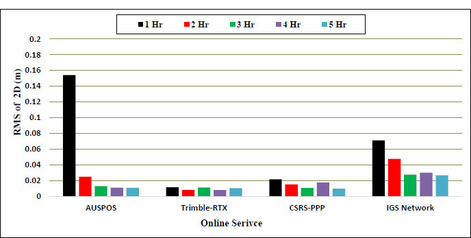
3.3. Results of IGS Network versus Results of Online Processing
Figs. (11 and 12) are provided. They compare the obtained RMSE values for the TBC and AUSPOS, CSRS-PPP so as Trimble-RTX, at the 5 SDs, for the Easting so as Northing and elevation, respectively.
However, it is of significance to mention the following:
• At this stage, a comparison between the IGS and online service was achieved.
• A comparison was held between the TBC and online services results.
Fig. (11) indicates the following:
• The Easting and Northing (i.e., 2-D) RMSE values differed by varying the SD.
• Trimble-RTX provided the highest 2-D accuracy for the 4hr-SD (i.e., 0.008 m).
• CSRS-PPP provided an RMSE, for the 2-D, of 0.01 m, for the 5hr-SD.
• AUSPOS recorded an accuracy for the 2-D, of 0.01 m, for the 5hr-SD.
• IGS network provided the lowest accuracy, for the 2-D, of 0.026 m 5hr-SD.
• Utilizing Trimble-RTX corrections yields superior accuracy in east-north coordinates.
Fig. (12) indicates the following:
• IGS network provided least accuracy for the 1hr-SD.
• IGS network provided better accuracies for the 2hr-SD or more.
4. DISCUSSION
This section provides a comparison between the results obtained from the IGS network, online service results and previous research.
The comparison revealed the following:
Firouzabadi et al.,2012 assessed the GPS precision as a function of session duration and reference frame using multi-point software at sessions 6 h or longer and four or more reference stations, the precision is typically 1–2 mm in horizontal and about 3–5 mm in vertical [30].
Stepniak et al., achieved the optimal data processing strategy in precise GPS leveling networks. The test network, spanning 20 km x 60 km, included 19 monitored points and 5 control points. Results indicate that precise GPS leveling approximately 3 mm repeatability in height measurements during 4-hour sessions [31].
Hebert et al., 2020 assessed the accuracy of online GNSS processing services, and their results indicated that the commercial software post-processing provided similar values (i.e., average RMSE = 0.004, 0.003 and 0.007 m in X, Y and Z, respectively) [32].
Mahmoud and Aziz, 2018 achieved an accuracy assessment of the free web-based online GPS processing services and the GPS software, and their results agreed with the obtained results (i.e., TBC maximum RMSE=0.005 m for 4hr-SD) [33].
By comparing the outcomes derived from this study, it is evident that they largely align with the findings of earlier research endeavors.
CONCLUSION
In this extensive study, we undertook a thorough evaluation of various online post-processing services and software designed for GNSS Data analysis. The primary focus encompassed three prominent solutions: Trimble Center Point RTX, AUSPOS, and CSRS-PPP, with an additional comparison to the International GNSS Service (IGS) Network. This study was conducted across diverse ground surfaces and involved sessions spanning durations of 1 hour, 2 hours, 3 hours, 4 hours, and 5 hours, allowing us to assess their impact on accuracy comprehensively. To begin with, the analysis utilizing the IGS processing method revealed that alterations in session duration had minimal influence on the east and north coordinates errors but significantly impacted elevation accuracy. The most optimal Root Mean Square Error (RMSE) values for east coordinates were achieved at the 3-hour and 5-hour marks, boasting an impressive accuracy of 0.02 meters. In contrast, height accuracy exhibited variability, with RMSE values ranging from 0.25 meters for the initial hour to a mere 0.06 meters for session durations spanning 2 to 5 hours. Consequently, it is recommended to employ a 3-hour session for enhanced east and north coordinates accuracy, while a 5-hour session is preferable for superior height accuracy. Next, a comparative analysis between IGS processing and online processing services unveiled that Trimble CenterPoint RTX offered the highest accuracy in 2D coordinates. Meanwhile, the IGS Network excelled in terms of height accuracy, rendering it the optimal choice for users with specific vertical precision requirements. Lastly, when assessing online processing services against the IGS Network, Trimble CenterPoint RTX consistently emerged as the frontrunner for 2D coordinates accuracy, achieving an impressive RMSE as low as 0.0081 meters during 4-hour sessions. CSRS-PPP also demonstrated competitive accuracy, while AUSPOS exhibited slightly higher errors. Notably, the IGS Network outperformed in height accuracy, particularly for session durations of 2 hours and beyond. Anticipate future research endeavors focused on examining the real-time precision of the IGS network and web-based online GPS services in dynamic conditions. Additionally, assess the impact of session-duration variation on accuracy in situations involving user movement or swift environmental changes.
LIST OF ABBREVIATIONS
| RINEX | = Receiver Independent EXchange |
| GNSS | = Global Navigation Satellite Systems |
| TB | = Trimble Business Center |
CONSENT FOR PUBLICATION
Not applicable.
AVAILABILITY OF DATA AND MATERIALS
This research was conducted in the laboratories of Al-Azhar University, and therefore the resulting data belongs to Al-Azhar University and cannot be published outside the university.
FUNDING
The study was self-funded, as I am pursuing a master's degree in Egypt, and there is no external financial support involved.
CONFLICT OF INTEREST
The authors declare no conflict of interest, financial or otherwise.
ACKNOWLEDGEMENTS
Declared none.

